
Short answer
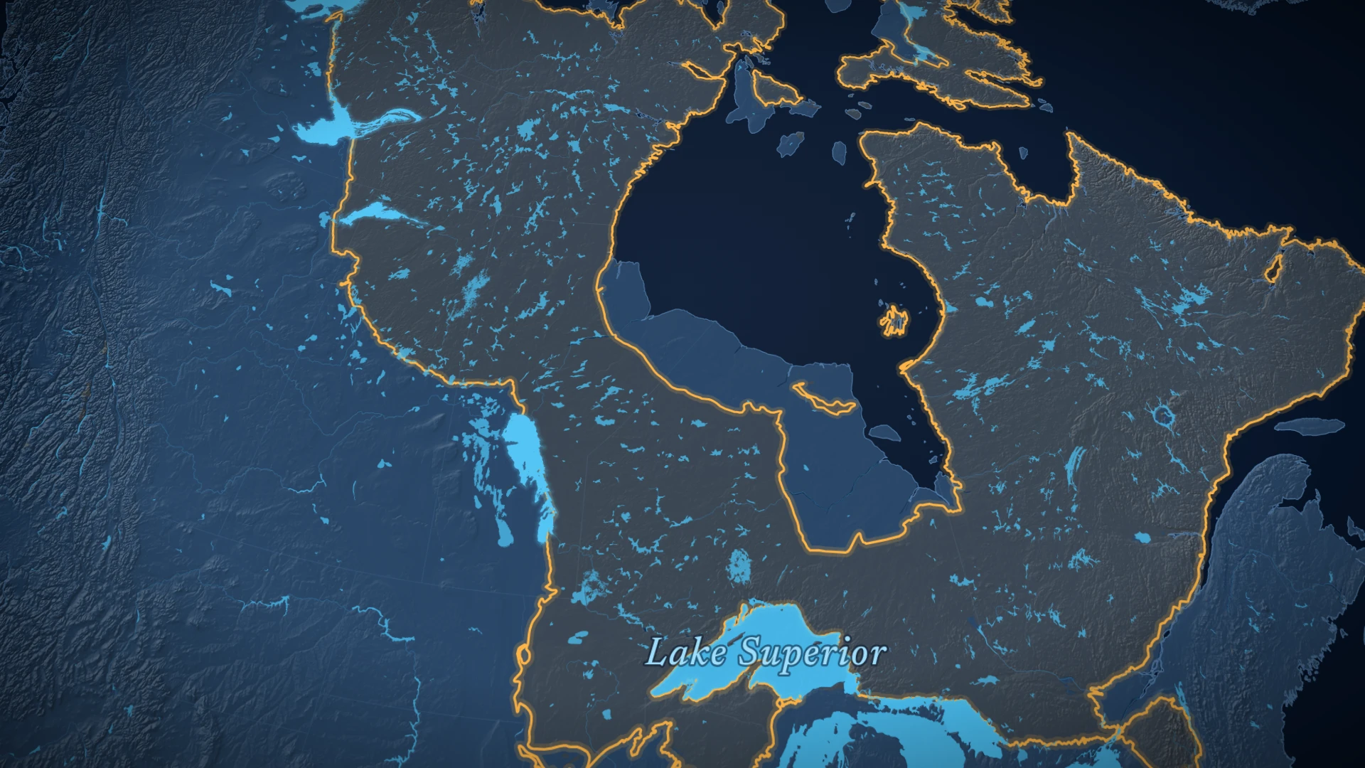
The big lakes sit where the hard, ancient rock of the Canadian Shield meets softer, younger layers of rock. Ice sheets wore the soft rock away along that edge, again and again, and left long hollows that filled with water. But each lake has its own story, and parts of it are still not settled.
The big picture
Why does Canada have so many lakes?
Canada has nearly 14 percent of the world’s lakes larger than 500 km².1 And most Canadian lakes were made by glaciers.1
Each dot is 1% of the world’s lakes bigger than 500 km². The blue dots are the ones in Canada.1
Long before the ice arrived, the land had already been worn down. Over a few hundred million years, erosion took away about 20 km of rock, until the land was almost flat. Then, about 600 million years ago, the sea flooded in.5 That sea laid down the softer layers you see in the video, on top of the hard Shield rock.6
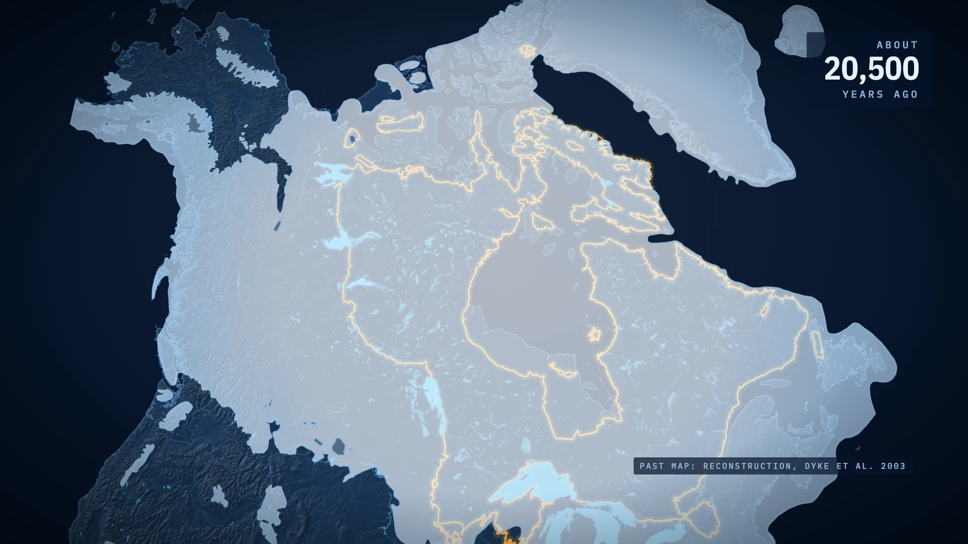
Then the ice came, again and again. In the last ice age alone, the ice spread out four times, and each time it made the hollows that hold the Great Lakes bigger.4 The ice also moved as it grew. Near Sudbury, in Ontario, it flowed from northeast to southwest, scraping the rock as it went.7
An old idea
Where does the idea of a line of lakes come from?
Geologists noticed long ago that the big lakes follow the edge of the Shield. One of them, named White, suggested that the edge of the soft limestone was peeled back a little more with each ice age. He called the curve it left an “arc of exhumation”, marked by large lake basins.6 Exhumation means digging something up. Here, the ice dug the old Shield rock out from under the younger layers.
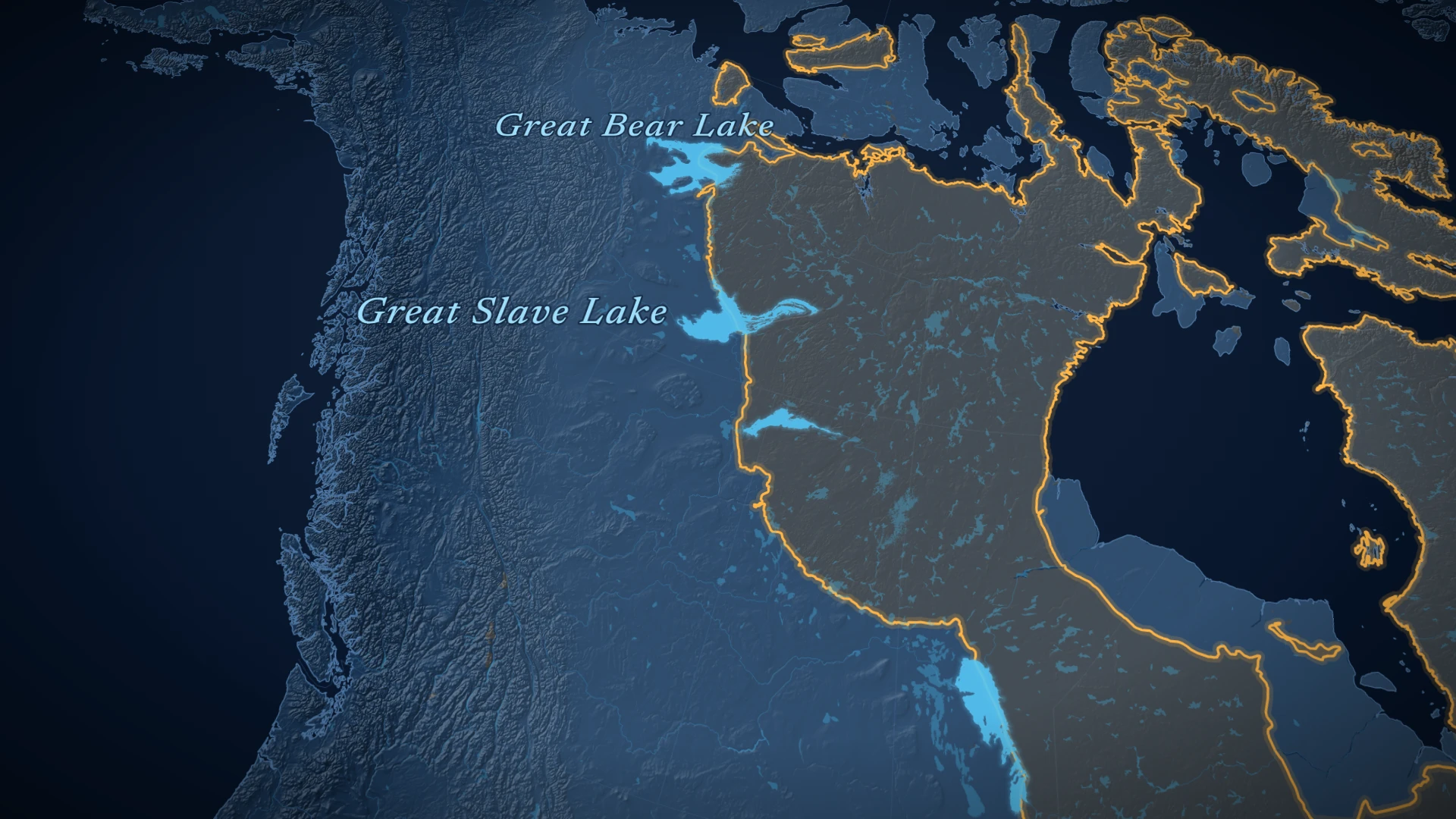
That explains the line, but not each lake’s own history. A 2021 study says no one is yet sure when or how the hollows of Great Bear, Great Slave, Athabasca and Winnipeg formed. It adds that they have been surprisingly little studied.6 The deepest lake of the four shows why.
Deeper than it looks
How deep is Great Slave Lake really?
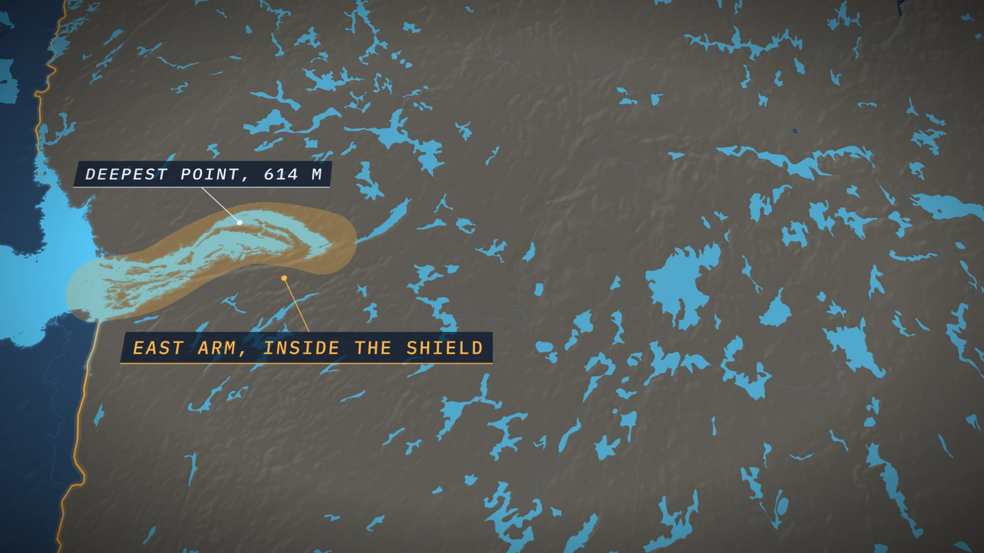
Great Slave Lake is the deepest lake in North America. Its deepest point, 614 m, is in Christie Bay, in the lake’s East Arm.2
But that is only the depth of the water. The hollow in the rock goes deeper. Christie Bay is a long, deep trench in the rock, about 100 km long.8 Under the water lies about 150 m of fine lake mud, on top of material the glaciers left behind. So the rock floor is deeper still.8
A crack in the crust
What made the East Arm of Great Slave Lake?
So what made such a deep trench? Look under the water and mud, and you find a long crack in the Earth’s crust, the McDonald Fault, running along the East Arm. It forms a straight cliff, with hard, granite-like rock on one side and soft, layered rock on the other.9 The rock on the two sides slid past each other sideways, by about 75 km.3
The same band of rock (amber), split by the fault and slid sideways. A sketch, not to scale.3
An idea its own author took back
In the 1970s, the Geological Survey of Canada mapped the East Arm. The team thought the East Arm was a failed rift: a place where the continent began to tear apart, then stopped.3 The video tells the same kind of story for Lake Superior.
But the geologist who put forward that idea, Paul Hoffman, later called it a disastrous mistake. Today geologists see the East Arm as the mark of a collision. Two ancient pieces of the continent, called the Slave and Rae cratons, were pushed into each other.9 That collision made faults where the rock slid sideways, the McDonald Fault among them.9
Even now, the work isn’t finished. The Northwest Territories Geological Survey is still pinning down when the East Arm’s rocks formed.10
After the ice
Is the land still moving?
Yes. Long after those ancient collisions, the ice sheet pressed the land down with its weight, as the video shows. Since the ice melted, the land has been slowly rising back up.4
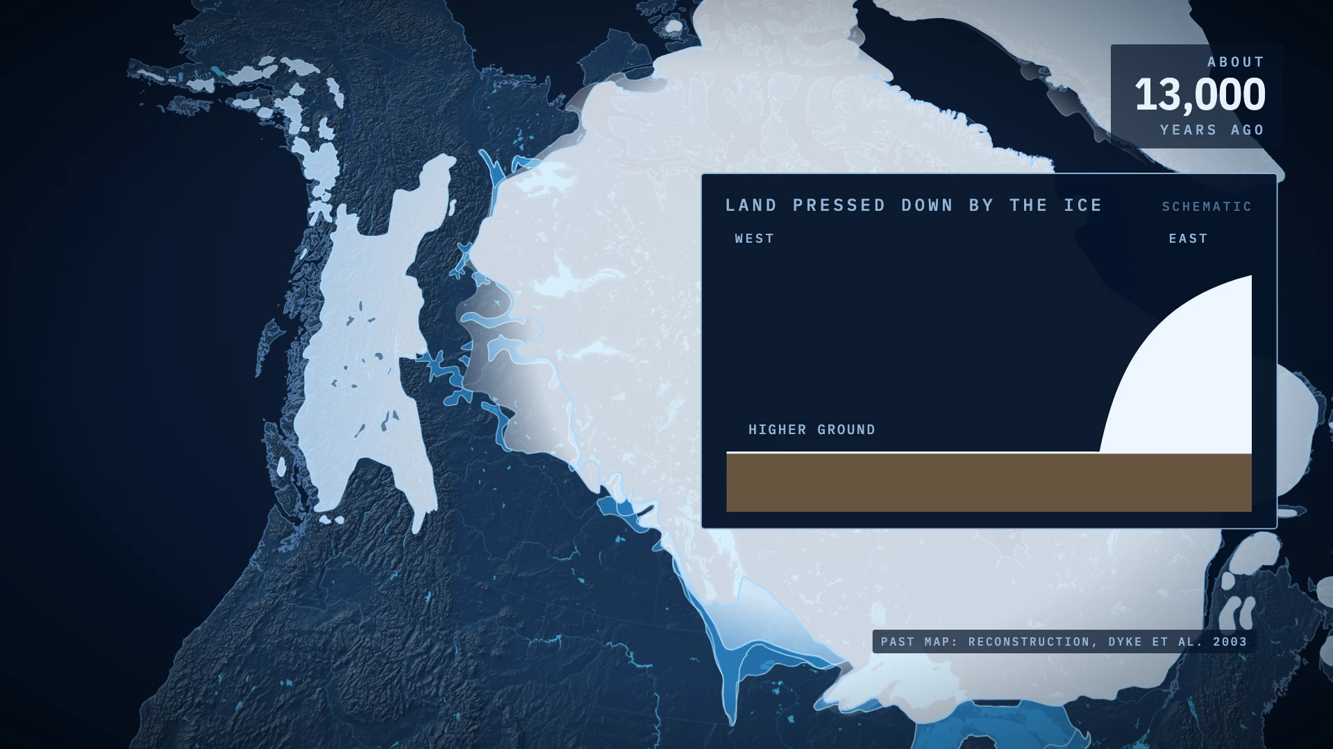
That slow rise helped drain the giant lakes left by the ice. As the ice kept melting and shrinking, the level of glacial Lake Agassiz dropped, and the places where its water spilled out moved.11 A lake stays at the same level only while the water coming in matches the water leaving: flowing out, drying up into the air, or soaking into the ground.1 When that balance changed, the old lakes shrank into the ones on today’s map.
Still open
What do geologists still not know?
Some of the biggest questions are still open:
- How old the basins are. The age and origin of the big lake basins are still not settled.6
- When the East Arm formed. Its rock layers are still being dated.10
- How much was ice, and how much was moving rock. Lake Superior, for example, was shaped by both glaciers and movements of the Earth’s crust.1
Quick answers
Questions people ask
Why are Canada's biggest lakes in a line?
They sit along the edge of the Canadian Shield, where hard, ancient rock meets softer, younger layers. Ice sheets wore the softer rock away along that edge over many ice ages, and left long hollows that filled with water.
How deep is Great Slave Lake?
614 m at its deepest point, in Christie Bay. That makes it the deepest lake in North America. About 150 m of mud lies under the water there, so the rock floor is deeper still.
Is the land in Canada still rising after the ice age?
Yes. The ice sheet pushed the land down, and since it melted, the land has been rising back. The northern shores of the Great Lakes rise about 0.4 m per century compared with the southern shores.
Sources
Every source on this page
Each number in the text links here. We keep a saved copy of every source, and the quote below each one is the line the claim rests on.
- 1The Canadian Encyclopedia: Lake
Canada has nearly 14 per cent of the world's lakes, with surface areas over 500 km 2 .
secondary source - 2The Canadian Encyclopedia: Great Slave Lake
The East Arm, which lies in the shield, is distinguished by numerous islands, complex shorelines, and great depths.
secondary source - 3Hoffman, Bell, Hildebrand and Thorstad 1977, GSC Paper 77-1A: Geology of the Athapuscow Aulacogen, East Arm of Great Slave Lake (author copy)
There i s about 75 km of dextral strike-slip, estimated from displacements of Wilson Island and Union Island Group rocks, on what is here termed the McDonald-Wilson Fault.
primary source - 4The Canadian Encyclopedia: Great Lakes
Postglacial isostatic uplift continues to raise the northern shorelines of the Great Lakes by about 0.4 m per century, relative to the southern shores of lakes Erie and Michigan.
secondary source - 5The Canadian Encyclopedia: Geological Regions
Erosion removed some 20 km of the crust over the next few 100 million years, so that when a great invasion of the sea began about 600 million years ago the landscape was almost flat.
secondary source - 6Bukhari et al. 2021, Boreas 50: Regional subglacial quarrying and abrasion below hard-bedded palaeo-ice streams crossing the Shield-Palaeozoic boundary of central Canada (CC BY 4.0)
Erosion of hard crystalline Canadian Shield rock was largely ineffectual
primary source - 7Ontario Geological Survey, Science North geotour (2021)
Ice flowed across the Greater Sudbury region from northeast to southwest.
primary source - 8Christoffersen et al. 2008, Geology: large subglacial lake beneath the Laurentide Ice Sheet inferred from sedimentary sequences (abstract page)
Here we explore the nature of a sedimentary succession in a deep tectonic trough identified as a prime candidate for a large subglacial paleolake. The trough is the 100-km-long, 620-m-deep Christie Bay, located in the east arm of the Great Slave Lake, Canada.
primary source - 9Hoffman 2012, Geoscience Canada 39(4), column 'The Tooth of Time: Charlie Roots' (East Arm of Great Slave Lake geology)
One of them, the McDonald Fault, presents a linear escarpment that parallels the east arm and puts granitoid basement rocks against the soft sedimentary succession.
primary source - 10NWT Geological Survey: Provenance of the East Arm Basin
The project aims to more thoroughly establish the stratigraphic timing and provenance of the various units in the Paleoproterozoic East Arm basin of Great Slave Lake
primary source - 11The Canadian Encyclopedia: Lake Agassiz
As deglaciation continued, lower lake levels were established and the overflow drainage shifted
secondary source
Next
Why trains still crash: the gaps the safety systems missTempi, Purley, Cuenca and the 1889 law behind railway signals: what our video on train crashes left out, in plain words, with every source.